Kokopelli Trail Run
May 22-23, 2004
141 miles / 32 hours, 47 minutes and 41 seconds of desert fun!
The Kokopelli Trail
is a wonderful route that goes from
Loma, in western Colorado, to Moab, Utah, through spectacular
and varied desert landscape. The best estimate of its length
(from knowledgeable mountain bikers) is 141 miles. The route
is mostly jeep and OHV tracks, with some single track and some
paved roads.
There's a map of the route here.
For a few years Buzz Burrell
and I talked about running the Kokopelli
Trail in one push. Somehow, we never got around to it. Then,
in April 2002, our friend Paul Pomeroy ("The Inscrutable Po")
drove the route one Friday laying caches of food and water,
then got up the next day and ran the whole thing solo in 37
hours and 33 minutes. We were impressed! Paul's typically
low-key report is
here.
Flash forward to May 2004.
Stephanie and I have a free weekend
and somehow recruit Kevin Taverner to drive support for us.
Without anywhere near adequate consideration or study of the
route, we decide to give the KT a try. Oh boy, here we go!
We drive from our home in Boulder, Colorado, on Friday afternoon
and camp at the Loma Boat Ramp. Its a noisy spot close to I-70 and
(we discover) a popular party spot for the local high school kids.
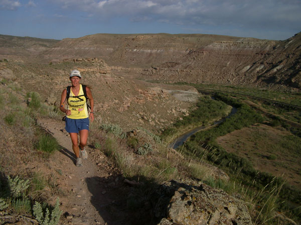
But its works. We wake up at 4:30 a.m. and are running at 5:31.
The morning is pleasantly cool and the desert is very beautiful
with many wildflowers in bloom. This section has some of the best
singletracks of the whole route, and is very popular with
mountain bikers, but it is early and we do not see anyone.
These trails were included in the route of the old Kokopelli
Marathon and 50 km races, and we reminisce a bit as we lope along
the canyon rim past lovely yellow and purple flowers.
At 12 miles the trail pops out onto a gravel road on a
bluff and we hit our first aid stop. Kevin has everything
unloaded from the 4Runner and spread out for us to immediately
grab whatever we want. He's fantastic! Kevin should hire
himself out as professional support crew.
Jogging along the gravel road to Rabbit Valley (20 miles) we
catch a view of the snow-capped La Sal mountains looming impossibly
far away to the southwest. We nearly lose heart with the realization
that our destination is on the other side of that distant range!
In the next section it starts to get hot and there is a very dry
wind. We are both feeling pretty intimidated by the distance.
What the hell have we gotten ourselves into? The trail makes a big
loop to the north, and we seem to be getting nowhere. We meet Kevin
again at the Westwater Road. Ice-cold and sweet Arizona Iced Tea
tastes wonderful! We are trying to settle into the day but having
some difficulty. I am clearly tired from running the
Massanutten 100 mile
two weeks ago, and Stephanie is, well, I guess just not warmed
up yet.
At 40 miles we leave the Westwater Road and are back on a dirt track
along the Denver & Rio Grande Railroad. Gradually our spirits improve.
Yes, we have a really, really long way to go, but we are shuffling along
and making decent time, averaging about 5 miles per hour. "This thing
is too runnable!" Stephanie exclaims. We need more walking breaks.
We run across wide open desert country near Cisco, Utah. Some dry storms
kick up, cooling things nicely, but we are battered by wind. Swaths of
the landscape are carpetted with orange-red flowers. The La Sals loom far
away, but noticeably closer and we are running right towards them.
At McGraw Bottom (63 miles) we see Kevin again and then cross Highway
128 and ascend the longest climb so far, still quite gradual. This is
followed by a long, sandy downhill past beautiful Entrada sandstone
bluffs.
We make it to the historic Dewey Bridge over the Colorado River just
before dark. Built in 1916 this bridge was considered an engineering
marvel. The old bridge remains for foot and bike traffic, while a new
bridge has been constructed for cars. Kevin has some nice hot soup and
the usual turkey and avocado sandwiches ready for us. At this point we
are roughly 4 hours ahead of Paul Pomeroy's time from two years ago, but
we know there is still a long way to go.
We alternate walking and running up the Entrada Bluffs Road as the daylight
fades. The sky is so clear that at 10 p.m. we can still see the faint glow
of the setting sun. As the stars come out the wind dies and the desert air
cools rapidly. The long climb up this gravel road is punctuated by two
steep, rocky downhill sections that are brutal on our tired legs. The
second, which loses over 1000 feet into Cottonwood Canyon, is especially
nasty. Travel is extremely slow and it takes us over 5.5 hours to complete
18 miles from Dewey Bridge to Fisher Valley. The guidebook says this is
a very beautiful section, but there is no moon and we can see nothing but
what is illuminated by the dim glow of our flashlights.
We toil on and on, with little idea of where we are or how long until we
will see Kevin again. We have climbed over 5000 feet since leaving Dewey
Bridge. We are down to our last sips of water and a couple of Clif Shots
when we finally encounter Kevin on North Beaver Mesa. What a relief!
After a good recharge break we hit the road again. 103 miles down!
Soon it begins to get light and we hope the new day will bring renewed
energy. Stephanie is having some trouble with her vision and we are
both suffering from nasty chafing. Still the road seems to go only
up & up & up. As some energy returns with daylight and more food we
are able once again to run the more gradual climbs. The landscape is
dramatically different from that we left in the low-lying desert. Now
we have lovely, sparse juniper forests, and the snow-capped La Sal
Mountains loom immediately above.
We top out on Fisher Mesa at 8500 feet and the road, now paved, immediately
plunges down 2000 feet in 6 miles to Castle Valley. Its nice to be able
to make good time, but I keep thinking this fast running on steep pavement
may spell the last gasp for my tired legs.
We reach Castle Valley a little after 9 a.m. Paul did the final 21 miles
in just about 5 hours, and we are hopeful we can come close to this split.
We have another 6 mile climb on paved road before the final huge downhill
into Moab. It feels good to walk and enjoy the expansive views of the
Castle Valley and the jagged Porcupine Rim to our right, and the La Sals
to our left. My stomach has been difficult for some time, but I keep
forcing down what I can and it seems to be working.
We see Kevin one last time where the Kokopelli Trail leaves the paved
La Sal Loop Road on a rough OHV track. Now the fun begins, a 15 miles
downhill losing 3,700 feet! We crank down the lovely OHV track along
Porcupine Rim, past some derelict mining equipment, and pop out onto the
Sand Flats Road. The road drops into Rill Canyon and the classic desert
scenery returns with lovely sandstone bluffs and spires. The Moab Valley
is spread before us, beaconing.
The parking area for the Porcupine Rim mountain bike trail markes the
final six miles, all gradual downhill. But, suddenly and out of nowhere
there is a sharp pain in the 5th metatarsal of my left foot! Six miles
to go and I am reduced to a hobble. I sit down and Stephanie massages
my foot, then I replace my shoe with the laces very loose. Still hurts.
I take off the shoe again and remove the arch support insole to relieve
pressure from the lateral side of my foot. Still hurts. Screw it, let's
get this thing done. The pain and slow pace are very frustrating at this
point, but we amble along the smooth road.
Finally the
Slickrock Bike Trail parking lot comes into view! Less than
half a mile to go and tears well up in our eyes as the pain and fatigue of
the last day and a half melt away into the desert and we run like horses
to the barn. Holding hands we cross our imaginary finish line laughing and
crying hysterically. Kevin is there, of course, and its big hugs all
around.
"Wow, that was a big one," I say, looking at my watch. "Let's go get a
shower."
Summary:
The Kokopelli Trail is a great, classic route! It has been a target
of mountain bikers for years, but is rarely run in its entirety. At
roughly 140 miles it is definitely on the long side to run in a
single push, but yet short enough to do with only one night out if a
concerted effort is made and adequate support is available. This
desert country can be very hot in summer, and the best season is
probably April and May. Earlier than that there could be snow at the
higher elevations in the La Sals. Fall is also good but of course you
have less daylight. The Kokopelli Trail would be very difficult to do
unsupported since there is no ambient water available on most of the
route. Much of the trail is very accessible via 2WD vehicle, so support
is not a big problem. Paul Pomeroy did the whole thing with only 5
resupply stops (which he laid out himself the previous day), while we
had many more. Nevertheless, there are still some difficult spots, and
we had one tough section of about 24 miles at night with no support.
We used a guidebook for the trail by Peggy Utesch that I found on my
bookshelf. This guide is might still be available, but it might also
be somewhat out of date. It has detailed
description of the route as well as maps. The
Colorado Plateau Mountain Bike Trail Association (COPMOBA)
has brochures and maps. The trail is adequately
marked with BLM markers and we never had any trouble following the
route.
SPLITS
Distances are based on the old COPMOBA brochure.
| MILES | SPLIT | TOD* |
| Loma | 0.0 | 0:00 | 5:31 |
| Rabbit Valley | 20.2 | 3:58 | 9:29 |
| Cisco Boat Launch | 56.9 | 6:32 | 16:01 |
| Dewey Bridge | 75.8 | 4:38 | 20:39 |
| Fisher Valley | 93.9 | 5:36 | 2:15 |
| Castle Valley | 117.4 | 6:54 | 9:09 |
| Slickrock Bike Trail | 142.0 | 5:10 | 14:19 |
TOTAL TIME 32:47:41
*TOD = Time Of Day